You are currently browsing the tag archive for the ‘Lake Wenatchee’ tag.
Saturday, July 27, 2013 – Mountain Biking
We actually planned to ride here last year, but the trails were temporarily closed on the day we picked (due to forest fires in the area.) We rode Alder Ridge trail instead. (Check out the trip report here. It includes images of the fires and a map showing where Minnow Ridge/Chikamin Tie is.)
This time we were good to go. Our friend joined us and even purchased the après ride beverages!
Minnow Ridge Trail #1524 and Chikamin Tie Trail #1561 are located near Lake Wenatchee, WA.
To get here, turn off Highway 2 onto Highway 207, then take the Chiwawa River Road. After passing the trailhead for Alder Ridge, turn onto road #6210.
In less than half mile, the trailhead for Chikamin Tie is on the right. (Road #6210 continues for several miles. Minnow Ridge trail basically parallels the road. Eventually, we crossed the road’s end to access the upper segment of the Chikamin Tie trail.)
The trailhead for Minnow Ridge Trail #1524 is also the trailhead for Chikamin Creek Trail #1534. We did not take that trail, but we talked to 2 motorcyclists who did. They said it has plenty of exposure (no, thanks!), as it contours a steep side hill– but it does offer a loop option for those interested.

This is not the trail we took, but this trail shares a trailhead with Minnow Ridge Trail.
Our trip was an “out and back.” Let’s begin!
SEGMENT 1
Minnow Ridge Trail #1524 starts at 2600 ft. After 3.5 miles and 900 ft net elevation gain of rolling ups and downs, you come to the intersection with Minnow Creek Trail #1539.

Eric consults the map at the first intersection.
SEGMENT 2
From the intersection, the last 2.3 miles of Minnow Ridge Trail continues up and down to meet up with Chikamin Creek. (The upper end of the Chikamin Creek Trail #1534 is located here.)

Stream crossing

Chikamin Creek
SEGMENT 3
This marks the start of Chikamin Tie Trail #1561. No more ups and down. The trail climbs steadily another 900 ft in 2 miles while it parallels the creek.

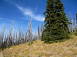
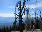
Stopping for a snack. If you look closely, you can see evidence of recent fire.
SEGMENT 4
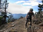
After being in shady forest all morning, we popped into the open sun to cross Road #6210 on our final climb above Chikamin Ridge.

Eric pops onto Road #6210, into the bright sun.
Here’s where we talked to the 2 motorcyclists. One ended up being a WA State Representative from the 12th District, Cary Condotta (R – East Wenatchee). I took his picture as he started up the upper Chikamin Tie trail.

We saw these 2 guys, plus one more small group of motorcyclists on the trail.

Cary Condotta
From here, I started feeling really strong.
It wasn’t because of sleep, because I slept like crap the night before. Maybe it was my “power breakfast” of a green smoothie (with avocado), non-dairy milk latte, and a spoon of peanut butter.
What I started thinking about, though, was an Endurance Planet podcast I heard this week (the episode with Dr. Jason Karp, co-author of Running For Women). In the podcast, I learned that a woman’s athletic performance can be best during the follicular phase of the menstrual cycle- in particular, when estrogen levels reach their peak.
I should be near that peak. Estrogen power!? Could it be? I was leaving the boys behind!
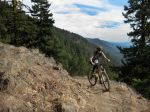
Before crossing a couple granite boulder fields, the trail surface became a bit rutted by motorcycle tires. It wasn’t really that bad, though (for me). It does require good core strength and bike handling to keep the front tire tracking straight.
The granite did require walking the bikes. That was the only real section of “hike-a-bike” during the whole trip.

First of 2 granite boulder fields to cross.

Our friend wanted to take some pictures here. We’re still on our way up, although Eric is posing for the “down.”

Onward and upward…

Part of Chikamin Ridge

Crossing the 2nd granite boulder field, below Chikamin Ridge.

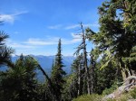
Surrounding hills.

I’m pretty sure that’s Clark Mountain with the snow on it.
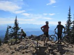
Above Chikamin Ridge, the upper Chikamin Tie Trail ended after 4.1 miles at a 3-way intersection (6200 ft).

I asked Eric to take my picture with this sign, and this is what I got. Super close-up!
SEGMENT 5
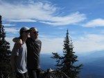
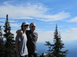
We were hoping for a spectacular view once we climbed above Chikamin Ridge, but we didn’t get it at the intersection. We’d basically arrived at our turnaround point, but now we were on a quest for views.
We continued onto Pond Camp Tie Trail #1409.2 toward a highpoint on the map at 6500 ft. (After that, the trail would drop down to Pond Meadow.)
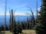
Here are the views we got. Okay, but anticlimactic…

Left side of our “view” from the 6500 ft highpoint.

Middle section views from 6500 ft highpoint.
The best was yet to come. The ride back to the car!
While screaming down the trail on the descent, I unofficially named both segments of the Minnow Ridge Trail “Superfun Forest.” The forest floor is basically smooth, with not too many of those switchbacks with the pesky waffle-pattern cement blocks (for the motorcycles.)
This trip is definitely one to repeat. I’d also like to explore a little further, toward Mad Lake/Meadow. This will require getting an earlier start.
The beer at the car really hit the spot. Good times!

Cheers!
————————————
TRIP STATS: (Using the Bike Tracks App for iPhone)
- Total Distance = 24.9 miles
- Total Vertical = 9349 ft (climb 4627 ft, descend 4722 ft)
- Elevation = 6462 ft highest, 2536 ft lowest
- Time = 8 hrs, 7 min (start 9:45 AM, finish 5:45 PM)
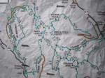
MAP USED:
FOOD CONSUMED ON TRAIL:
- Water + SaltSticks
- 1 square homemade Sunflower Butter Energy Bar (GF)
- 2 pieces dried mango
- 3 jumbo black olive
- 4 salted cashews
- 1 energy gel (with caffeine)
Alder Ridge – Mountain Bike – September 15, 2012
This mountain bike ride to Alder Ridge (trail 1523) was actually “Plan B.” Our intended ride was Chickamin Tie (trail 1561) via Minnow Ridge (trail 1524). Although the Chickamin trails were open when we checked, they were closed at some point before we arrived at the trailhead. The closures are/were due to extensive forest fire activity in the area.
The Alder Ridge trailhead is located just down the road from the Chickamin trails. This is near Lake Wenatchee, WA. To get there, turn off Highway 2 onto Highway 207, then take the Chiwawa River Road to the well-marked trailhead. This general area is called the Entiat/Mad River/Lower Chiwawa area.
This was a solid day trip and worthy of a repeat. We started at 2400 ft and climbed steadily to a high point of 6200 ft in about 8 1/2 miles. The singletrack tread was mostly smooth toward the bottom and a bit more rocky toward the top. It was “steepish” but mostly “rideable.” (Subjective, I know!) I felt strong and I didn’t have to get off my bike too many times 🙂 . Due to dry conditions, the trail was sandy in places, but not bad. Dust…yes, there was plenty of that. The descent was a blast and over too fast!
This is a multiple use trail system…which means that our fresh air was briefly fouled with the toxic fumes of several motorcycles on the ascent. (Cough, cough – deep, forceful exhales!!) That was the only negative part of the trip. Fortunately, the motor traffic was probably “light” due to the fire closures.
Our biking group of 3 vegans and 1 omnivore also met a pair of hunters. They seemed nice enough, though I’ll never understand how anyone can take pleasure in killing a deer.
After that, I rode on, repeating silently in my mind over and over…
“I manifest good luck to the animals in the forest.”
Click on an image to enlarge and view the photos in a gallery. In the photos, you will see maps of the area, views of Glacier Peak, and views from our high point of 6200 ft. (We didn’t quite make it to Mad Lake.) We photographed the Basalt Peak fire to the north and the Wenatchee fires to the south.
-

- Alder Ridge Trailhead
-

- Chiwawa River Valley

-

- Devils Backbone, Entiat, Mad River, Lower Chiwawa Sign
-
- Alder Ridge Trail Map
-

- Green Trail Map #146 – Plain, WA

-

- Basalt Peak Fire
-

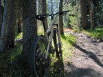
- Alder Ridge Trail
-

- Alder Ridge Trail
-
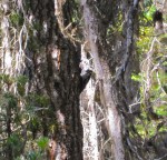
- Downy Woodpecker
-
- Glacier Peak
-

- Glacier Peak
-
- Old Forest Fire on Alder Ridge
-
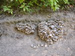
- What kind of mushroom?
-
- Santa Cruzin’ the Forest
-

- Wenatchee Fire View 1
-
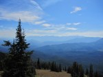
- Wenatchee Fire View 2
-

- Wenatchee Fire View 3
-
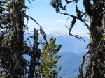
- Glacier Peak
-
- The Boys at 6200 ft
-

- Basalt Peak Fire
-

- Glacier Peak & Basalt Peak Fire
-

- Elisa & Eric
-
- Elisa & Eric
-
- Elisa & Eric

-

- Flat Tire on Alder Ridge
-

- Burned Tree
-

- Wenatchee Fire
-
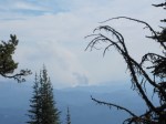
- Wenatchee Fire (Zoom)
-
- Elisa at Alder Ridge (Photo Credit: Ken H)
-
- Elisa at Alder Ridge (Photo Credit: Ken H)